We have often written about Duck Stamp-acquired wildlife refuges that are large in scale and dramatic in aspect, be they Hart Mountain National Antelope Refuge or Blackwater National Wildlife Refuge. But there is a landscape that is critical to the breeding success of North American waterfowl that some might consider humdrum in appearance, and whose public lands are managed as a mosaic of tiny units. Savvy readers know it as the northern Great Plains’ Prairie Pothole Region (PPR).
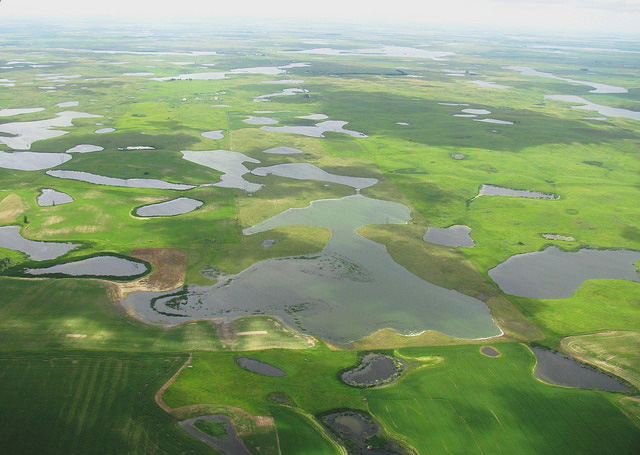
The PPR consists of 276,000 square miles, stretching from central Alberta southeastward into northern Iowa; parts of five U.S. states lie in the PPR. While “prairie” can refer to any of various ecosystems of moderate rainfall and temperate climate where the dominant vegetation is grasses, herbs, and shrubs (as opposed to trees), what sets the PPR apart is the abundance of wetlands formed during the Wisconsin glaciation, which ended about 10,000 years ago. The glaciers left shallow depressions known as potholes or kettle lakes. These pothole wetlands are not connected by surface streams; rather, they are fed by spring snowmelt (and to a lesser extent, groundwater flows).
This patchwork of temporary and semi-permanent wetlands is the continental nursery for many North American Anatidae species, our waterfowl. Prairie potholes are exceptionally productive because their shallow waters warm up quickly in spring; their dynamic nature facilitates nutrient cycling and the regrowth of vegetation and macroinvertebrates. The wetlands have been under threat for a century and half, largely due to drainage for agriculture; the adverse effect on breeding birds was decried as early as 1927 by Iowan W. J. Berry. Nevertheless, by one estimate, the PPR still produces 50% of the North American breeding waterfowl population. Recent open access research by Neal D. Niemuth, Kathleen K. Fleming, and Ronald E. Reynolds assesses 40 years of population data; the authors suggest that continued draining and intensified land use remain the most significant threats to PPR birds, rather than other factors, such as climate change.
The grasslands in the region, going back to swaths that emerged from the ice sheet millennia ago and that have never been impacted by a shovel, constitute a precious native habitat that begs for conservation. Globally, grasslands are the most human-altered biome with the highest risk of biome extinction. Only about 18% of the grassland in the U.S. Prairie Pothole Region is protected, which equates to just 5% of historic grass area. In comparison, about a third of the wetlands, which are sprinkled throughout these grasslands, are protected. Moreover, these important grasslands buffer and protect the individual wetlands, provide cover for young waterfowl, and are crucial for numerous at-risk grassland songbirds—from longspurs, to pipits, to sparrows.
Like the mosaic of wetlands, public land management in the PPR is similarly broken into small pieces, characterized as having “a complex and sometimes confusing legislative history [with] funding from multiple sources….” Unlike the situation farther west, less than 10% of the landscape is under private, state, or federal protection programs (1992 data). The Department of Agriculture (USDA), through the Natural Resources Conservation Service, offers incentives to farmers to forego conversion of wetlands to croplands; it has enrolled more than 430,000 acres in wetland easements. USDA’s Conservation Reserve Program (CRP) has nationwide scope, but it has been quite strong in the PPR. The Prairie Pothole Joint Venture, one of the original six partnerships among federal agencies, state offices, and NGOs established under the North American Waterfowl Management Plan, has been conserving habitat since 1987. This joint venture, through its web of partnerships, protects, restores, and enhances high priority wetland and grassland habitats to help sustain populations of waterfowl, shorebirds, waterbirds, and prairie landbirds on the U.S. portion of the PPR.
Perhaps most important our readers would be the USFWS’s Small Wetlands Program, which has used funds from the Duck Stamp program to protect nearly 3 million acres of habitat, most of it in the PPR. The program was created in 1958 by an amendment to 1934’s Migratory Bird Hunting and Conservation Stamp Act and was strengthened by the Wetland Loan Act of 1961. Rather than acquiring large tracts of land, the Small Wetlands Program uses fee-title and easements to secure small patches called Waterfowl Production Areas (WPAs). Some of these units are tiny, the smallest being Ward County WPA in North Dakota, spanning only 0.1 acre (only as much land as your correspondent’s townhouse sits on), but there are a lot of them. All told, 36,000 WPAs comprise 18% of Refuge System lands in the lower 48. Small, numerous, and hugely important—WPAs are wetland conservation’s “long tail”.
Administratively, WPAs are organized into Wetland Management Districts (WMDs), which are coterminous with counties in which any land is managed as a WPA. In the Prairie Pothole Region states, there are 32 WMDs.
Spellman Lake WPA, 393 acres in Yellow Medicine County, Minnesota, and Big Slough WPA, comprising 800 acres of Murray County in the same state, have been featured by USFWS. A project by Darrel Drake, Brenda Tozer, and Geoffrey Stillwell does a good job of pulling together maps of the geology, hydrology, and meteorology of the PPR. Ducks Unlimited produced a 6-minute video in 2010 from the PPR with some lovely clips of ducks afloat and on the wing.
WPAs in the U.S. Prairie Pothole Region, acquired by fee-title and easement, are one more set of valuable investments in America’s conservation portfolio. They’re made possible when you purchase your Duck Stamp.
A version of this article first appeared in the 25 September 2017 issue of Wingtips.